Case Details
Client: Sell My Car Pty Ltd
Location: Melbourne, Australia

Branch Locations - Geostatistics & Geospatial Research

Background & Requirements

Sell My Car is a car buying service. Interested customers visit buying centres, have their vehicle inspected and receive an offer for purchase.

The client was looking to identify potential new buying centre locations.

In addition, the client wished to understand:
    (1) How far customers were willing to travel and how long they were willing to travel for
    (2) What the impact would be of opening up buying centres in strategically positioned locations


Understanding the impact was particularly important. The client needed to have forecast the incremental additional vehicles purchased and the volume that would shift to this proposed buying centre from other currently opened buying centres.
image
Solution

OSGeo Analysis

Athena IT Limited worked with the client to gather user postcode and suburb data.

Using information from Australia Post, the valuation and appointment postcode data was geocoded to a specific location and aggregated.

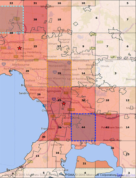
Postcode regions were converted into shapes in OSGeo, these shapes and ratios of valuations to appointments and appointments to purchases was overlaid onto a map of Australia.

Using the ratio of appointments (has value) to valuations (no value) it was possible to identify regions of opportunity.

Proposed buying centre regions were modelled to show the incremental additional volume and the forecast impact on conversion rate.

As part of this analysis, we identified the effect each extra minute of travel time and extra KM travelled had on customers' willingness to book an appointment and sell their car.

Outcome

Two buying centres were opened. To this day, the volumes of vehicles purchased at these buying centres are generally among the best performing Australia-wide.

Send a Message

Let Athena IT know about your project or initiative, we will write back to discuss further